Precission and Smart Farming

Satellite based remote sensing for increased revenue from farming

Who We Are

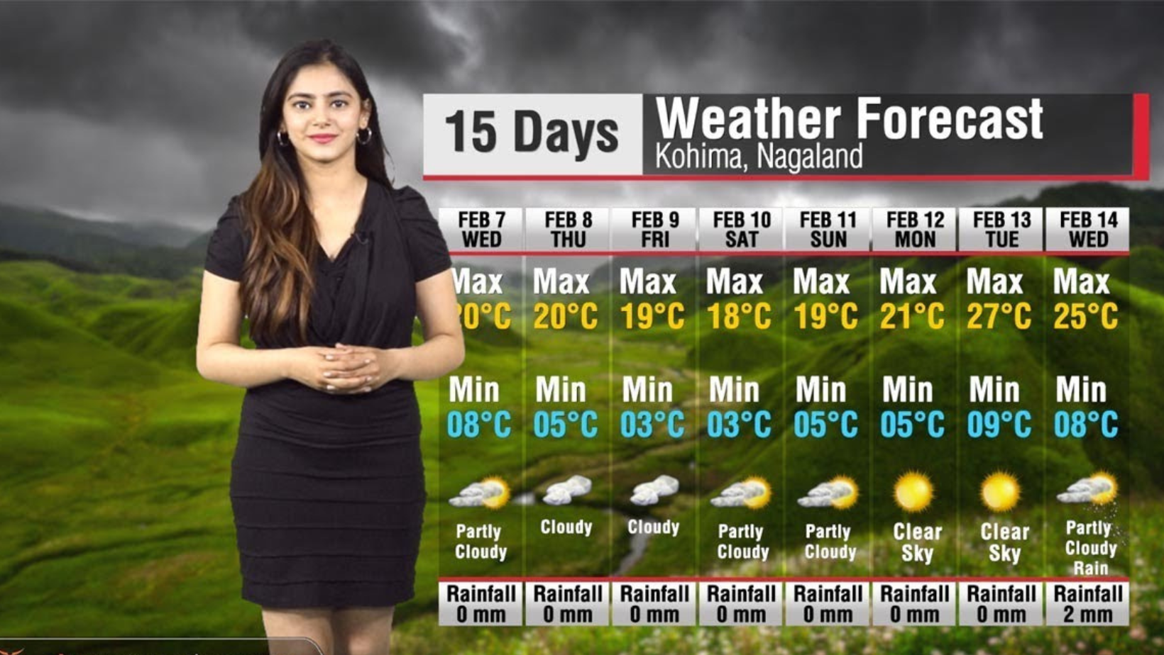
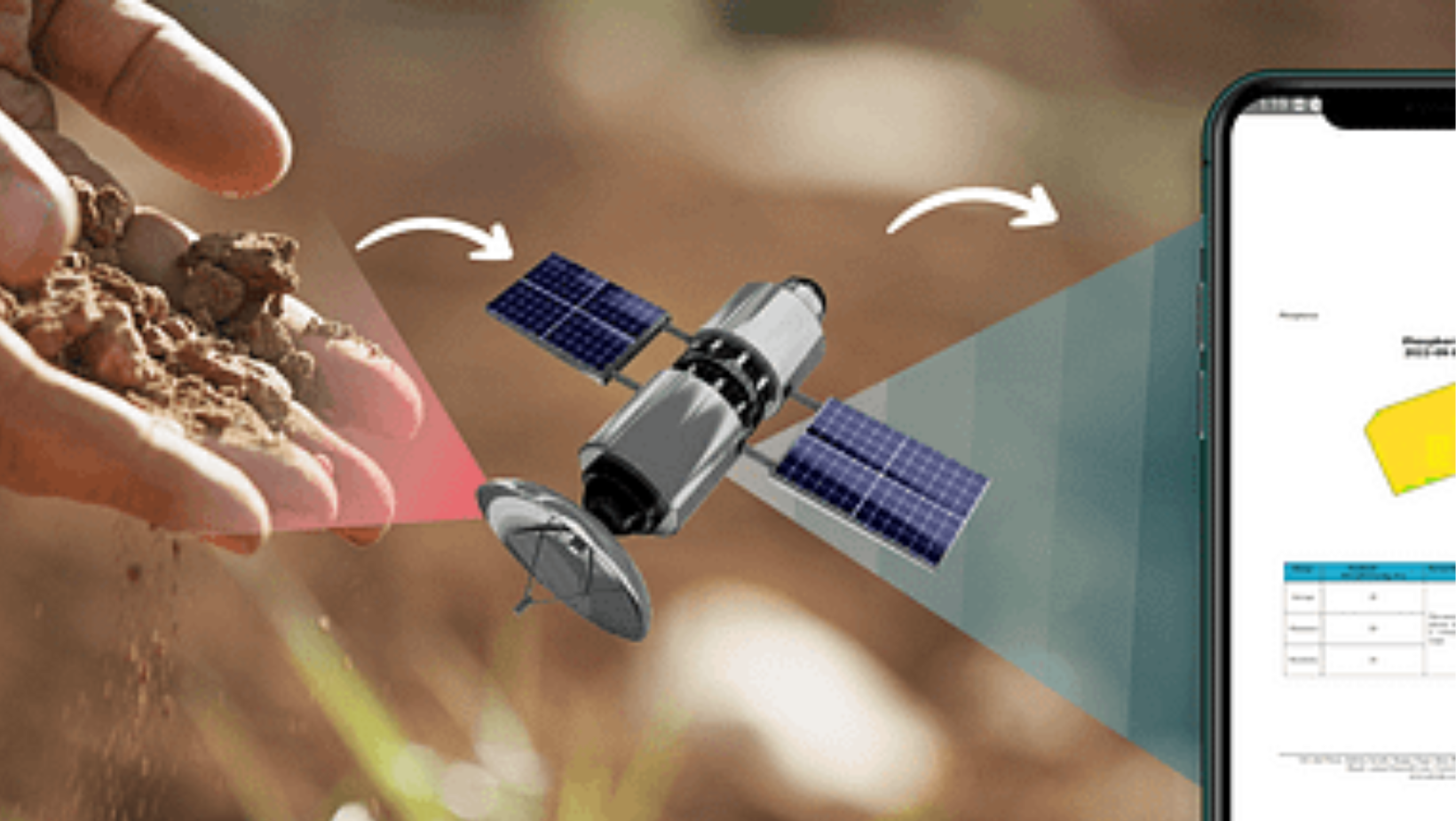
Satellite based farm monitoring helps in better agri management and boost of income.

KisanSAT is a satellite-based agriculture advisory service for issues relating to agriculture and a crop management concept that is more beneficial for increased crop yield. Agri-experts with extensive expertise working in several areas of agriculture make up the KisanSAT team. However, people are still reliant on physically inspecting the crops in nations like India, where everyone cannot afford monitoring devices. As a result, a satellite-based solution is needed, and satellite photos are frequently used for this.

Services

Using satellite based remote sensing we offer following services to farmers.

Soil based rapid soil nutrients analysis

With KisanSat, the laborious and time-consuming procedure of soil macronutrient testing for each and every farm will be completed quickly and painlessly, and the results will be provided directly to the farmer for reference. The soil health parameters nitrogen (N), phosphorus (P), potassium (K), soil organic carbon (OC), and pH can be estimated with the use of KisanSAT.

Pest and disease forewarning

The application's camera feature allows users to send immediate advice to farmers. To predict potential pest and disease attacks, KisanSAT combines satellite data with meteorological forecast information such as wind speed, temperature, humidity, rainfall, and cloud cover.

Satellite-based crop health analysis

The NDVI, EVI, RVI, and other crop health indicators can be used to precisely pinpoint the site of a crisis, allowing you to concentrate on the most pressing problem at hand rather than inspecting every inch of the field. For prompt action, KisanSAT provides data on the health and development of field crops at various phases of plant growth.

Image-based diagnosis for pests and diseases

In order to deliver a real-time scientific diagnosis, KisanSAT analyses the real-time uploaded photos of pest- and disease-affected leaves or plants using machine learning and artificial intelligence algorithms.

Weather forecast for 15 days

Get the weather forecast for the next 15 days and schedule your farming tasks (such as planting and harvesting) accordingly. In order to address issues with pest and disease attack, KisanSAT gives preweather forecasts for 15 days on parameters and variables such as wind direction, temperature, humidity, rainfall, clouds, etc.

Satellite-based soil moisture estimation (SME)

KisanSAT assists farmers in determining the type of crop that can be produced in the soil and in discovering possible surface water available for crop uptake throughout their entire field. A farm's or field's estimated soil moisture from KisanSAT can tell you where or how much a crop is being watered there. Additionally, it aids farmers in selecting the best irrigation systems and water management techniques based on the water content that will be available over time.

Crop and location-based calendar-specific for more than 50 crops

To ensure timely farm operations and lower the risk of excessively using priceless farm resources like inputs, irrigation water, pesticides, fungicides, etc., specific and recommended practises are always available for each of the crops farmed. More than 50 different crops are covered by the KisanSAT crop calendar, which can offer timely information for better farming practises like planting, sowing, irrigation, harvesting, and applying pesticides and fertilisers.

Land Area Mapping in Acre/Hectare/Bigha

Using satellite data, KisanSAT measures an accurate area of your land in various local units like- Bigha/ Guntha/ Acre or Hectare in minutes. It will help you to measure accurate land dimensions of your land and also save time of farmers.

Estimation of optimal irrigation requirement

Determine whether a particular soil is moisture deficient or not and helps in planning the irrigation needs for obtaining satisfactory yields. The irrigation advisory provided will not only help the farmers in planning their irrigation needs but will also benefit the farmers by ensuring minimum wastage of water resources ensuring more yield per drop of irrigation water.

Pricing

Check our Pricing

SILVER

888
180 Days
  • Satellite-based rapid soil nutrients (N, P, K, OC, pH)
  • Satellite-based soil moisture estimation
  • Satellite-based crop health analysis
  • Weather forecast for next 15 days
  • Pest & Disease forewarning
  • Image-based diagnosis of Pest & Disease
  • Crop and location-specific calendar for 150 crops
  • Land Area Mapping in Acre/Hectare/Bigha
  • Identifies Nutrients Deficiency in Crop
  • Estimation of optimal irrigation requirement
  • 03% Extra Disccount on Purchase Order of Rs.999 and more
  • 05% Discount on Agri- enterprenuership Training Programme
  • Free Contract Farming Consultation
  • Free Agri Commodity Export Consultaiton
Buy Now
Featured

GOLD

1350
360 Days
  • Satellite-based rapid soil nutrients (N, P, K, OC, pH)
  • Satellite-based soil moisture estimation
  • Satellite-based crop health analysis
  • Weather forecast for next 15 days
  • Pest & Disease forewarning
  • Image-based diagnosis of Pest & Disease
  • Crop and location-specific calendar for 150 crops
  • Land Area Mapping in Acre/Hectare/Bigha
  • Identifies Nutrients Deficiency in Crop
  • Estimation of optimal irrigation requirement
  • 03% Extra Disccount on Purchase Order of Rs.999 and more
  • 05% Discount on Agri- enterprenuership Training Programme
  • Free Contract Farming Consultation
  • Free Agri Commodity Export Consultaiton
Buy Now